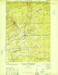
1945 Map of Stratford
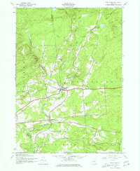
USGS Topo · Published 1977About this map
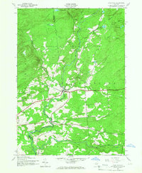
Adirondack State Park encompasses much of this mid-1940s landscape, where the southern boundary of the park intersects the rugged border between Herkimer and Fulton Counties. The settlement of Stratford serves as a primary hub along the banks of East Canada Creek, with several smaller crossroads like Emmonsburg and Knappville scattered across the surrounding hills. This survey, based on aerial photography from the war years, captures the region's transition from a logging and agricultural frontier into a managed forest. Significant local landmarks such as Roundtop Cem and School No 18 indicate established community roots even as the wilderness remained dominant. The drainage patterns of Stony Brook, Sprite Creek, and the Aqueduct demonstrate the critical role of water management in this high-elevation terrain, while summits like Oak Mtn and Bear Hill anchor the local topography.
Find a feature on this map
28 named features on this map. Tap any name to fly to it.
Don’t see what you’re looking for? This feature index may not catch every label — zoom into the map to look around manually.
Map Details
Editions of this 1945 Stratford Map
4 editions found

Other maps of this area

1900 · Little Falls
USGS Topo · 1:62,500

1900 · Wilmurt
USGS Topo · 1:62,500

1901 · Lassellsville
USGS Topo · 1:62,500

1902 · Wilmurt
USGS Topo · 1:62,500

1903 · Lassellsville
USGS Topo · 1:62,500

1903 · Little Falls
USGS Topo · 1:62,500

1904 · Piseco Lake
USGS Topo · 1:62,500

1906 · Piseco Lake
USGS Topo · 1:62,500

1908 · Piseco Lake
USGS Topo · 1:62,500

1939 · Little Falls
USGS Topo · 1:62,500