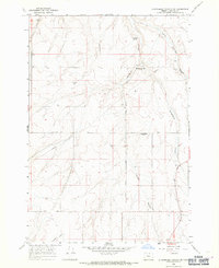
1968 Map of Strawberry Canyon SW
USGS Topo · Published 1971About this map
Strawberry Canyon and its complex network of seasonal drainage's dominate this high desert landscape of Morrow County. Photographed in the mid-1960s, the terrain reveals a transition from active cattle ranching and dry-land farming to the preservation of earlier homesteading footprints. The map specifically identifies the Strawberry (Site), a former community location along Strawberry Road, and the McDaid Springs (Site), indicating where previous water-dependent settlements once stood. These sites, along with multiple wells and a Storage Bin, reflect the resource-driven settlement patterns of the Oregon interior. Significant geographical markers include the Base Line and prominent natural features like Little Juniper Canyon and McMillen Canyon, which carve through the plateau towards the Columbia River basin.
Find a feature on this map
17 named features on this map. Tap any name to fly to it.
Don’t see what you’re looking for? This feature index may not catch every label — zoom into the map to look around manually.
Map Details
Editions of this 1968 Strawberry Canyon SW Map
2 editions found
Other maps of this area

1906 · Blalock Island
USGS Topo · 1:125,000

1908 · Blalock Island
USGS Topo · 1:125,000

1953 · Pendleton
USGS Topo · 1:250,000

1956 · Pendleton
USGS Topo · 1:250,000

1968 · Swaggart Buttes
USGS Topo · 1:24,000

1968 · Lexington
USGS Topo · 1:24,000

1968 · Ione North
USGS Topo · 1:24,000

1968 · Ione South
USGS Topo · 1:24,000
1968 · Strawberry Canyon NE
USGS Topo · 1:24,000
1968 · Strawberry Canyon SE
USGS Topo · 1:24,000