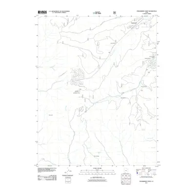
2011 Map of Strawberry Point
USGS Topo · Published 2011About this map
Strawberry Point and its high-elevation plateau dominate this southern Utah landscape, characterized by deep incisions and drainage systems such as Muddy Creek and Willis Creek. The 2011 survey reveals a quiet aviation presence with both the Strawberry Valley Estates Airport in the north and the Swains Creek Airport further east, serving the isolated residential developments emerging in this terrain. Roads like Bonanza Rd and Willis Creek Rd provide the primary access into these high valleys, where seasonal settlements are concentrated near the Strawberry Point View Area.
Find a feature on this map
39 named features on this map. Tap any name to fly to it.
Don’t see what you’re looking for? This feature index may not catch every label — zoom into the map to look around manually.
Map Details
Editions of this 2011 Strawberry Point Map
This is the sole edition of this map. No revisions or reprints were ever made.
Other maps of this area

1886 · Kanab
USGS Topo · 1:250,000

1953 · Cedar City
USGS Topo · 1:250,000

1954 · Orderville Canyon SE
USGS Topo · 1:24,000

1957 · Orderville Canyon NE
USGS Topo · 1:24,000

1958 · Cedar City
USGS Topo · 1:250,000

1958 · Orderville
USGS Topo · 1:62,500

1958 · Cedar Breaks
USGS Topo · 1:62,500

1958 · Panguitch Lake
USGS Topo · 1:62,500

1962 · Cedar City
USGS Topo · 1:250,000
1980 · Clear Creek Mountain
USGS Topo · 1:24,000