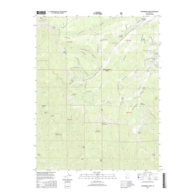
2017 Map of Strawberry Point
USGS Topo · Published 2017About this map
The Markagunt Plateau defines the high-elevation topography of this region within the Dixie National Forest. A complex network of recreational paths, including the Virgin River Rim Trail and Lars Fork Snowmobile Trail, crisscrosses the landscape, reflecting a modern economy centered on seasonal residents and backcountry tourism. Significant geological features such as the Pink Cliffs and Strawberry Point provide sharp vertical relief against the plateau's drainage systems. To the northeast, Strawberry Valley Estates represents a concentrated residential pocket supported by the Strawberry Valley Estates Airport. The southern half of the map is dominated by deep incisions like Orderville Gulch and Right Fork Lydias Canyon, where numerous isolated water sources like Deer Spring and Twin Springs emerge from the canyon walls.
Find a feature on this map
66 named features on this map. Tap any name to fly to it.
Don’t see what you’re looking for? This feature index may not catch every label — zoom into the map to look around manually.
Map Details
Editions of this 2017 Strawberry Point Map
This is the sole edition of this map. No revisions or reprints were ever made.
Other maps of this area

1886 · Kanab
USGS Topo · 1:250,000

1953 · Cedar City
USGS Topo · 1:250,000

1954 · Orderville Canyon SE
USGS Topo · 1:24,000

1957 · Orderville Canyon NE
USGS Topo · 1:24,000

1958 · Cedar City
USGS Topo · 1:250,000

1958 · Orderville
USGS Topo · 1:62,500

1958 · Cedar Breaks
USGS Topo · 1:62,500

1958 · Panguitch Lake
USGS Topo · 1:62,500

1962 · Cedar City
USGS Topo · 1:250,000
1980 · Clear Creek Mountain
USGS Topo · 1:24,000