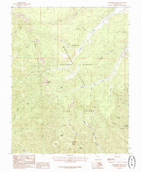
1985 Map of Strawberry Point
USGS Topo · Published 1985About this map
Strawberry Point serves as a prominent landmark on this mid-1980s survey of the Markagunt Plateau, where the elevation drops dramatically along the Pink Cliffs. The landscape is dominated by a complex network of canyons and drainage systems within the Dixie National Forest, including the deeply incised Orderville Gulch and the headwaters of Strawberry Creek. Named features like Shingle Mill Canyon suggest the historic timber and resource use that characterized this part of Kane County. The map details the transition from high plateaus to the intricate gullies of the Right Fork Lydias Canyon and Left Fork Lydias Canyon. Isolated water sources such as Twin Springs, Trough Spring, and Hidden Spring are critical points in this high-altitude environment, providing essential data for those studying the pastoral or geological history of the region.
Find a feature on this map
36 named features on this map. Tap any name to fly to it.
Don’t see what you’re looking for? This feature index may not catch every label — zoom into the map to look around manually.
Map Details
Editions of this 1985 Strawberry Point Map
This is the sole edition of this map. No revisions or reprints were ever made.
Other maps of this area

1886 · Kanab
USGS Topo · 1:250,000

1953 · Cedar City
USGS Topo · 1:250,000

1954 · Orderville Canyon SE
USGS Topo · 1:24,000

1957 · Orderville Canyon NE
USGS Topo · 1:24,000

1958 · Cedar City
USGS Topo · 1:250,000

1958 · Orderville
USGS Topo · 1:62,500

1958 · Cedar Breaks
USGS Topo · 1:62,500

1958 · Panguitch Lake
USGS Topo · 1:62,500

1962 · Cedar City
USGS Topo · 1:250,000
1980 · Clear Creek Mountain
USGS Topo · 1:24,000