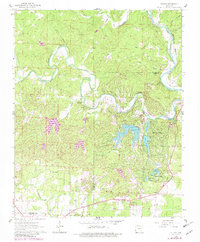
1962 Map of Stuart
USGS Topo · Published 1982About this map
The South Fork Spring River and the Spring River converge in this Ozark borderland, creating a landscape defined by significant water development and recreational growth in the early 1960s. The map captures the emergence of planned communities like Cherokee Village and Hidden Valley, characterized by their intricate networks of residential drives such as Pontiac Drive and Algonquin Circle. Numerous artificial water bodies, including Thunderbird Lake and Lake Sequoyah, are central to the area's mid-century layout, with a dam under construction noted near the Fulton and Sharp County line.
Find a feature on this map
45 named features on this map. Tap any name to fly to it.
Don’t see what you’re looking for? This feature index may not catch every label — zoom into the map to look around manually.
Map Details
Editions of this 1962 Stuart Map
4 editions found
Other maps of this area

1957 · Poplar Bluff
USGS Topo · 1:250,000

1959 · Poplar Bluff
USGS Topo · 1:250,000

1960 · Poplar Bluff
USGS Topo · 1:250,000

1962 · Stuart
USGS Topo · 1:24,000

1962 · Ash Flat
USGS Topo · 1:24,000

1962 · Myron
USGS Topo · 1:24,000

1962 · Agnos
USGS Topo · 1:24,000

1962 · Mammoth Spring
USGS Topo · 1:24,000
1962 · Camp
USGS Topo · 1:24,000

1968 · Hardy
USGS Topo · 1:24,000