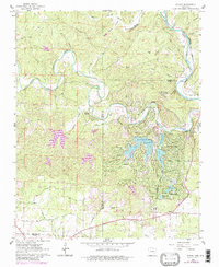
1962 Map of Stuart
USGS Topo · Published 1982About this map
Cherokee Village and its neighboring developments dominate this landscape at the border of Fulton and Sharp counties, where planned residential growth meets the winding hydrology of the Ozarks. The expansion of suburban-style infrastructure is evident through an extensive network of named drives, including Okmulgee Drive and Pontiac Drive, centered around man-made water bodies like Thunderbird Lake and Lake Sequoyah. This modernization contrasts with the older rural fabric of the region, marked by family burial grounds such as Hersperger Cem and the small rail-side settlement of Stuart.
Find a feature on this map
57 named features on this map. Tap any name to fly to it.
Don’t see what you’re looking for? This feature index may not catch every label — zoom into the map to look around manually.
Map Details
Editions of this 1962 Stuart Map
4 editions found
Other maps of this area

1957 · Poplar Bluff
USGS Topo · 1:250,000

1959 · Poplar Bluff
USGS Topo · 1:250,000

1960 · Poplar Bluff
USGS Topo · 1:250,000

1962 · Stuart
USGS Topo · 1:24,000

1962 · Ash Flat
USGS Topo · 1:24,000

1962 · Myron
USGS Topo · 1:24,000

1962 · Agnos
USGS Topo · 1:24,000

1962 · Mammoth Spring
USGS Topo · 1:24,000
1962 · Camp
USGS Topo · 1:24,000

1968 · Hardy
USGS Topo · 1:24,000