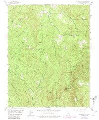
1947 Map of Stumpfield Mtn.
USGS Topo · Published 1981About this map
The Sierra National Forest dominates this section of the Sierra Nevada foothills, where the Chowchilla River and its multiple forks carve through steep elevations. This 1947 survey, later updated in 1981, reveals a landscape defined by isolated rural schoolhouses and high-altitude landmarks. Indian Peak Sch sits tucked beneath the summit of Indian Peak in the southern portion of the map, while Chowchilla Sch serves the area near Elliott Corner to the north.
Find a feature on this map
31 named features on this map. Tap any name to fly to it.
Don’t see what you’re looking for? This feature index may not catch every label — zoom into the map to look around manually.
Map Details
Editions of this 1947 Stumpfield Mtn. Map
4 editions found
Other maps of this area

1897 · Yosemite
USGS Topo · 1:125,000

1900 · Yosemite
USGS Topo · 1:125,000

1903 · Yosemite
USGS Topo · 1:125,000

1909 · Yosemite
USGS Topo · 1:125,000

1912 · Mariposa
USGS Topo · 1:125,000

1947 · Mariposa
USGS Topo · 1:24,000

1947 · Mariposa
USGS Topo · 1:250,000

1947 · El Portal
USGS Topo · 1:62,500

1947 · Mariposa
USGS Topo · 1:62,500

1947 · Buckingham Mtn
USGS Topo · 1:24,000