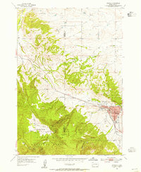
1954 Map of Sturgis
USGS Topo · Published 1955About this map
Sturgis serves as the focal point of this mid-century survey, situated where the high plains meet the eastern edge of the Black Hills National Forest. The town’s 1950s infrastructure is clearly visible, including the High Sch, Sturgis Landing Field, and a local Hospital. The Chicago and North Western railroad provides the primary industrial artery, tracking through the valley alongside Bear Butte Creek. Outside the central settlement, the landscape is defined by rural education and topographical landmarks. Several country schools, such as Eden Sch, Merritt Sch, and Boulder Park Sch, are scattered across the terrain, indicating the distribution of ranching and timber communities of the era. To the west, the map transitions into the steep elevations of Oyster Mountain and Granite Peak, while Boulder Park and Deadman Gulch illustrate the rugged drainage patterns that define the northern Black Hills region.
Find a feature on this map
24 named features on this map. Tap any name to fly to it.
Don’t see what you’re looking for? This feature index may not catch every label — zoom into the map to look around manually.
Map Details
Editions of this 1954 Sturgis Map
3 editions found
Other maps of this area

1893 · Rapid
USGS Topo · 1:125,000

1894 · Deadwood
USGS Topo · 1:125,000

1898 · Rapid
USGS Topo · 1:125,000

1899 · Sturgis
USGS Topo · 1:62,500

1901 · Deadwood
USGS Topo · 1:125,000

1903 · Rapid
USGS Topo · 1:125,000

1905 · Saint Onge
USGS Topo · 1:62,500

1906 · Vale
USGS Topo · 1:62,500

1907 · Belle Fourche
USGS Topo · 1:125,000

1913 · Newell
USGS Topo · 1:125,000