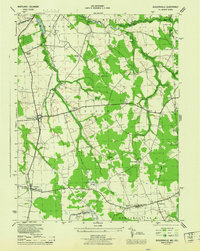
1944 Map of Sudlersville
USGS Topo · Published 1944About this map
The agrarian landscape of the upper Delmarva Peninsula is defined by the intersection of Queen Anne's and Kent counties, centered on the railroad hub of Sudlersville. During this mid-war era, the Pennsylvania railroad line serves as the primary spine of commerce, connecting the major village of Barclay to the surrounding rural hamlets. The terrain is a network of slow-moving water, where the Unicorn Branch and Andover Branch meander through a mix of dense woodland and scattered brush.
Find a feature on this map
47 named features on this map. Tap any name to fly to it.
Don’t see what you’re looking for? This feature index may not catch every label — zoom into the map to look around manually.
Map Details
Editions of this 1944 Sudlersville Map
This is the sole edition of this map. No revisions or reprints were ever made.
Other maps of this area

1899 · Dover
USGS Topo · 1:125,000

1900 · Cecilton
USGS Topo · 1:62,500

1905 · Barclay
USGS Topo · 1:62,500

1906 · Dover
USGS Topo · 1:125,000

1920 · Dover
USGS Topo · 1:125,000

1926 · Wyoming
USGS Topo · 1:48,000

1930 · Wyoming
USGS Topo · 1:62,500

1931 · Wyoming
USGS Topo · 1:62,500

1931 · Smyrna
USGS Topo · 1:62,500
1944 · Church Hill
USGS Topo · 1:31,680