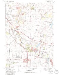
1993 Map of Sugar Grove
USGS Topo · Published 1994About this map
Blackberry Creek meanders through this portion of Kane County, carving a path through a landscape defined by glacial features and the expanding suburban footprint of the early 1990s. The topographic relief is punctuated by prominent elevations such as Johnsons Mound, located within the Johnsons Mound County Forest Preserve, and Bald Mound further east. This period shows a transition from rural agricultural land, marked by numerous Gravel Pits and a Quarry, toward more developed uses including the Aurora Municipal Airport and the campus of Waubonsee Community College. Local heritage is anchored by the Sugar Grove Cem and various community worship sites like the Village Bible Church. The presence of the East-West Tollway signals the region's role as a growing transportation corridor connecting smaller settlements like Nottingham Woods to the larger urban center of Aurora.
Find a feature on this map
69 named features on this map. Tap any name to fly to it.
Don’t see what you’re looking for? This feature index may not catch every label — zoom into the map to look around manually.
Map Details
Editions of this 1993 Sugar Grove Map
This is the sole edition of this map. No revisions or reprints were ever made.
Other maps of this area

1925 · Yorkville
USGS Topo · 1:62,500

1932 · Geneva
USGS Topo · 1:62,500

1937 · Sycamore
USGS Topo · 1:62,500

1948 · Geneva
USGS Topo · 1:62,500

1948 · Sandwich
USGS Topo · 1:62,500

1949 · Geneva
USGS Topo · 1:24,000

1950 · Sandwich
USGS Topo · 1:62,500

1950 · Aurora North
USGS Topo · 1:24,000

1953 · Yorkville
USGS Topo · 1:24,000
1954 · Aurora South
USGS Topo · 1:24,000