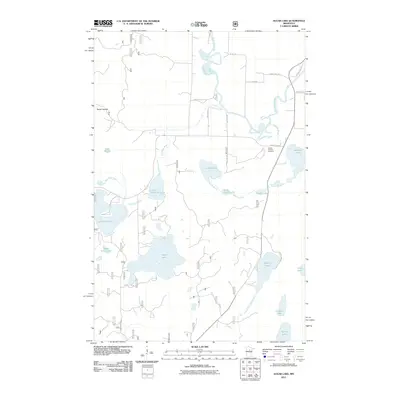
2011 Map of Sugar Lake
USGS Topo · Published 2011About this map
The Mississippi River winds through the northern portion of this landscape in Itasca County, defining a complex network of wetlands and interconnected waterways. Further south, the Vermillion River feeds into several namesake basins, including Vermillion Lake and Little Vermillion Lake. The central focus of the quadrangle is Sugar Lake, surrounded by smaller bodies of water such as Dead Horse Lake and Lake Sixteen. This area is characterized by its glacial hydrology, where drainage is managed through smaller tributaries like Dan Dick Creek and Leighton Brook.
Find a feature on this map
35 named features on this map. Tap any name to fly to it.
Don’t see what you’re looking for? This feature index may not catch every label — zoom into the map to look around manually.
Map Details
Editions of this 2011 Sugar Lake Map
This is the sole edition of this map. No revisions or reprints were ever made.
Other maps of this area

1953 · Siseebakwet Lake
USGS Topo · 1:24,000

1953 · Cohasset West
USGS Topo · 1:24,000

1954 · Hibbing
USGS Topo · 1:250,000

1957 · Hibbing
USGS Topo · 1:250,000

1958 · Hibbing
USGS Topo · 1:250,000

1964 · Hibbing
USGS Topo · 1:250,000

1970 · Big Thunder Peak
USGS Topo · 1:24,000
1970 · Deer River
USGS Topo · 1:24,000

1970 · Ball Club
USGS Topo · 1:24,000
1971 · Remer
USGS Topo · 1:24,000