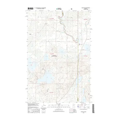
2016 Map of Sugar Lake
USGS Topo · Published 2016About this map
The Chippewa National Forest dominates this northern landscape where the Mississippi River meanders through the northeastern corner. This area of Itasca County is defined by a dense network of water bodies and interconnected river systems, including the Vermillion River and its accompanying Little Vermillion Lake. A poignant local landmark, the Paulley Children Cem, is located near the eastern boundary, offering a specific point of interest for genealogical research in this otherwise predominantly wilderness and timber-managed region.
Find a feature on this map
43 named features on this map. Tap any name to fly to it.
Don’t see what you’re looking for? This feature index may not catch every label — zoom into the map to look around manually.
Map Details
Editions of this 2016 Sugar Lake Map
This is the sole edition of this map. No revisions or reprints were ever made.
Other maps of this area

1953 · Siseebakwet Lake
USGS Topo · 1:24,000

1953 · Cohasset West
USGS Topo · 1:24,000

1954 · Hibbing
USGS Topo · 1:250,000

1957 · Hibbing
USGS Topo · 1:250,000

1958 · Hibbing
USGS Topo · 1:250,000

1964 · Hibbing
USGS Topo · 1:250,000

1970 · Big Thunder Peak
USGS Topo · 1:24,000
1970 · Deer River
USGS Topo · 1:24,000

1970 · Ball Club
USGS Topo · 1:24,000
1971 · Remer
USGS Topo · 1:24,000