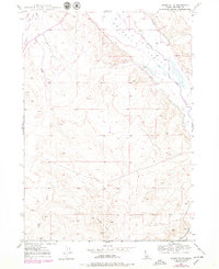
1947 Map of Sugar Valley
USGS Topo · Published 1979About this map
Sugar Valley is defined by its arid canyonlands and agricultural water management in the late 1940s, with later revisions from the 1970s reflecting minor infrastructure changes. The Bruneau River cuts through the northeast, supported by the Hot Spring Canal which channels water for the surrounding high desert ranching or farming operations. The terrain transitions from the valley floor to the rising elevations of Horse Hill and various washes including Sugar Creek.
Find a feature on this map
11 named features on this map. Tap any name to fly to it.
Don’t see what you’re looking for? This feature index may not catch every label — zoom into the map to look around manually.
Map Details
Editions of this 1947 Sugar Valley Map
2 editions found
Other maps of this area

1946 · Mouth of Bruneau
USGS Topo · 1:24,000

1947 · Little Valley
USGS Topo · 1:24,000

1947 · Bruneau
USGS Topo · 1:62,500

1947 · Sand Dunes
USGS Topo · 1:24,000

1947 · Bruneau
USGS Topo · 1:24,000

1947 · Sugar Valley
USGS Topo · 1:24,000

1947 · Hot Spring
USGS Topo · 1:24,000

1948 · Sand Dunes
USGS Topo · 1:24,000
1948 · Little Valley
USGS Topo · 1:24,000

1948 · Sugar Valley
USGS Topo · 1:24,000