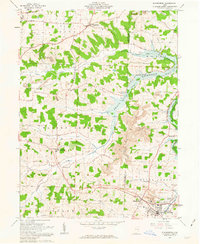
1961 Map of Sugarcreek
USGS Topo · Published 1963About this map
The Greenville Treaty Line bisects this landscape, marking a historical boundary between the United States Military District and Congress Lands. This division shapes the local geography, where the rolling hills of Holmes and Tuscarawas Counties meet at the Beach City Reservoir. The area is defined by tight-knit communities such as Winesburg and Shanesville, along with the industrial hub of Sugarcreek. The settlement pattern reflects a strong rural heritage, evidenced by numerous family-named burial grounds like Miller-Mast Cem, Yoder Cem, and Hardscrabble Cem. Extractive industry and transport are prominent, with several Strip Mines appearing near Barrs Mills and the New York Chicago and St Louis railroad cutting through the eastern corridor. Agriculture and industry coexist here, from the Kilns at the edge of town to the quiet reaches of Indian Trail Creek.
Find a feature on this map
41 named features on this map. Tap any name to fly to it.
Don’t see what you’re looking for? This feature index may not catch every label — zoom into the map to look around manually.
Map Details
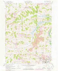
Editions of this 1961 Sugarcreek Map
2 editions found
Other maps of this area

1911 · Newcomerstown
USGS Topo · 1:62,500

1913 · Newcomerstown
USGS Topo · 1:62,500

1913 · Coshocton
USGS Topo · 1:62,500

1914 · Navarre
USGS Topo · 1:62,500

1915 · Millersburg
USGS Topo · 1:62,500

1915 · Coshocton
USGS Topo · 1:62,500

1943 · Millersburg
USGS Topo · 1:62,500

1943 · Coshocton
USGS Topo · 1:62,500

1943 · Newcomerstown
USGS Topo · 1:62,500

1944 · Navarre
USGS Topo · 1:62,500