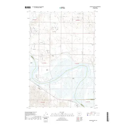
2017 Map of Sugarloaf Butte
USGS Topo · Published 2017About this map
The Missouri River dominates this 2017 landscape, carving through the heart of the region and defining the boundary between Morton and Burleigh counties. Along its western banks, the land is marked by significant alluvial features such as Schmidt Bottom, Kimball Bottom, and Graner Bottom, where the river's influence on the local topography is most apparent. This area includes the northern reaches of Lake Oahe, a major reservoir that has altered the river's traditional flow. Away from the water, the terrain rises into distinct elevations like Sugarloaf Butte and Twin Buttes. The settlement of Huff sits near the southern edge of the map, anchored by Saint Martins Cem, while further north, the Stewartsdale Cem serves as a marker of local heritage. The convergence of Apple Creek and the river, alongside the Roughrider Trail, highlights a landscape shaped by both natural drainage and modern recreational routes.
Find a feature on this map
62 named features on this map. Tap any name to fly to it.
Don’t see what you’re looking for? This feature index may not catch every label — zoom into the map to look around manually.
Map Details
Editions of this 2017 Sugarloaf Butte Map
This is the sole edition of this map. No revisions or reprints were ever made.
Other maps of this area

1907 · Bismarck
USGS Topo · 1:125,000

1950 · Bismarck
USGS Topo · 1:24,000

1951 · Menoken SW
USGS Topo · 1:24,000

1951 · Bismarck
USGS Topo · 1:62,500

1951 · Menoken
USGS Topo · 1:62,500

1954 · Bismarck
USGS Topo · 1:250,000

1958 · Bismarck
USGS Topo · 1:250,000

1962 · Sugarloaf Butte
USGS Topo · 1:24,000

1962 · Schmidt
USGS Topo · 1:24,000

1962 · Menoken SW
USGS Topo · 1:24,000