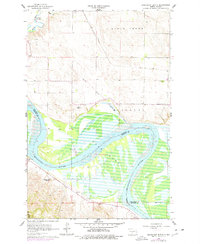
1976 Map of Sugarloaf Butte
USGS Topo · Published 1977About this map
The Missouri River corridor south of Bismarck is defined by the expansive waters of Lake Oahe and the surrounding high ground of the Missouri Plateau. This mid-1970s documentation reveals a landscape where modern water management meets deep frontier history, most notably evidenced by the Old Fort Rice Military Reservation Boundary cutting across the terrain. The map captures the small community of Huff near the southern edge and the isolated Manning School No 1 further north, reflecting the sparse, rural settlement pattern of Burleigh and Morton Counties.
Find a feature on this map
14 named features on this map. Tap any name to fly to it.
Don’t see what you’re looking for? This feature index may not catch every label — zoom into the map to look around manually.
Map Details
Editions of this 1976 Sugarloaf Butte Map
This is the sole edition of this map. No revisions or reprints were ever made.
Other maps of this area

1907 · Bismarck
USGS Topo · 1:125,000

1950 · Bismarck
USGS Topo · 1:24,000

1951 · Menoken SW
USGS Topo · 1:24,000

1951 · Bismarck
USGS Topo · 1:62,500

1951 · Menoken
USGS Topo · 1:62,500

1954 · Bismarck
USGS Topo · 1:250,000

1958 · Bismarck
USGS Topo · 1:250,000

1962 · Sugarloaf Butte
USGS Topo · 1:24,000

1962 · Schmidt
USGS Topo · 1:24,000

1962 · Menoken SW
USGS Topo · 1:24,000