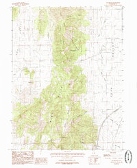
1983 Map of Sugarloaf
USGS Topo · Published 1985About this map
West Hills and Long Ridge dominate the central topography of this 1980s Utah survey, creating a natural divide between Dog Valley and Juab Valley. The drainage patterns here are well-defined by numerous steep-walled cuts including Cazier Canyon, Government Canyon, and Hall Canyon, which channel seasonal water eastward toward the valley floor. Water sources such as Government Spring and Orme Spring provided vital points of utility in this arid environment, likely serving local livestock operations or early range management needs.
Find a feature on this map
19 named features on this map. Tap any name to fly to it.
Don’t see what you’re looking for? This feature index may not catch every label — zoom into the map to look around manually.
Map Details
Editions of this 1983 Sugarloaf Map
2 editions found
Other maps of this area

1885 · Manti
USGS Topo · 1:250,000

1885 · Sevier Desert
USGS Topo · 1:250,000

1895 · Manti
USGS Topo · 1:250,000

1951 · Santaquin
USGS Topo · 1:62,500

1951 · Nephi
USGS Topo · 1:62,500

1953 · Delta
USGS Topo · 1:250,000

1954 · Tintic Mountain
USGS Topo · 1:24,000

1956 · Price
USGS Topo · 1:250,000

1958 · Delta
USGS Topo · 1:250,000

1960 · Price
USGS Topo · 1:250,000