
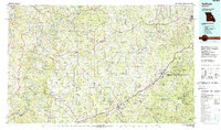
1985 Map of Sullivan
USGS Topo · Published 1985About this map
The Meramec River and Bourbeuse River carve through this central Missouri landscape, where the iron-rich geology of the Ozark Plateau is evidenced by the massive Pea Ridge Mine and the Old Christy Mine. This 1985 survey captures the regional hub of Sullivan alongside smaller railroad towns like Bourbon and Cuba that grew along the St Louis-San Francisco RR. The map highlights a transition from industrial mining and agriculture to conservation, showing the established boundaries of Meramec State Park and the subterranean landmarks of Meramec Caverns and Onondaga Cave. Local genealogy is well-supported by numerous rural institutions, from the Spring Bluff Church and St Cloud Church to isolated sites like Veto and Safe. Higher elevations such as Pilot Knob and Cave Hill define the terrain between the river valleys and the sprawling Mark Twain National Forest.
Find a feature on this map
172 named features on this map. Tap any name to fly to it.
Don’t see what you’re looking for? This feature index may not catch every label — zoom into the map to look around manually.
Map Details
Editions of this 1985 Sullivan Map
3 editions found
Other maps of this area

1886 · Jefferson City
USGS Topo · 1:125,000

1888 · Tuscumbia
USGS Topo · 1:125,000

1890 · Hermann
USGS Topo · 1:125,000

1890 · Fulton
USGS Topo · 1:125,000

1894 · Tuscumbia
USGS Topo · 1:125,000

1894 · Jefferson City
USGS Topo · 1:125,000

1901 · De Soto
USGS Topo · 1:125,000

1903 · O'Fallon
USGS Topo · 1:125,000

1903 · Sullivan
USGS Topo · 1:125,000
1906 · Potosi
USGS Topo · 1:62,500