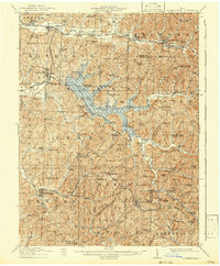
1911 Map of Summerfield
USGS Topo · Published 1942About this map
The hills of Guernsey and Noble counties are defined here by a dense network of early 20th-century rural infrastructure, where schools and churches served small farming communities separated by the winding drainages of Seneca Fork Wills Creek and Beaver Creek. The Baltimore and Ohio RR cuts across the northern landscape, anchoring settlements like Quaker City and Salesville, while the southern interior is marked by local landmarks such as Beatty Knob Mt Ephraim and Aiken Ridge.
Find a feature on this map
103 named features on this map. Tap any name to fly to it.
Don’t see what you’re looking for? This feature index may not catch every label — zoom into the map to look around manually.
Map Details
Editions of this 1911 Summerfield Map
This is the sole edition of this map. No revisions or reprints were ever made.
Other maps of this area
1903 · Macksburg
USGS Topo · 1:62,500
1903 · Flushing
USGS Topo · 1:62,500
1905 · New Matamoras
USGS Topo · 1:62,500
1905 · Woodsfield
USGS Topo · 1:62,500
1905 · Flushing
USGS Topo · 1:62,500
1905 · Macksburg
USGS Topo · 1:62,500
1909 · Antrim
USGS Topo · 1:48,000
1909 · Caldwell
USGS Topo · 1:62,500
1909 · Summerfield
USGS Topo · 1:62,500

1909 · Cambridge
USGS Topo · 1:62,500