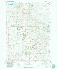
1979 Map of Summit Reservoir
USGS Topo · Published 1986About this map
Bennett Hills and the Black Butte Hills define this high-desert landscape in south-central Idaho, where water management is the primary signature of human activity. The terrain is marked by an extensive network of small reservoirs and springs, including Summit Reservoir, Granite Butte Reservoir, and the descriptively named Flat Tire Reservoir. These catchment areas, often paired with infrastructure like the Brailsford Well or Association Well, reveal the necessities of ranching and survival in a region characterized by prominent volcanic features and lava flows. The Union Pacific rail line skirts the northeastern corner near Little Magic Res, providing a lone industrial corridor through a territory otherwise defined by remote jeep trails and named watering holes like One Hour Reservoir and Bailing Reservoir.
Find a feature on this map
44 named features on this map. Tap any name to fly to it.
Don’t see what you’re looking for? This feature index may not catch every label — zoom into the map to look around manually.
Map Details
Editions of this 1979 Summit Reservoir Map
2 editions found
Other maps of this area

1955 · Hailey
USGS Topo · 1:250,000

1957 · Thorn Creek SE
USGS Topo · 1:24,000

1957 · Thorn Creek
USGS Topo · 1:62,500

1957 · Bellevue
USGS Topo · 1:62,500

1957 · Blaine
USGS Topo · 1:62,500

1959 · Hailey
USGS Topo · 1:250,000

1962 · Hailey
USGS Topo · 1:250,000

1979 · Shoshone Ice Cave
USGS Topo · 1:24,000
1979 · Kinzie Butte
USGS Topo · 1:24,000

1979 · Summit Reservoir
USGS Topo · 1:24,000