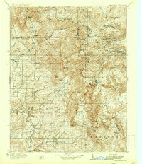
1915 Map of Summitville
USGS Topo · Published 1937About this map
The Continental Divide snakes through this high country, separating the San Juan National Forest from the Rio Grande National Forest. In the early twentieth century, this region was a rugged landscape of mining camps and isolated cattle operations. The settlement of Summitville sits perched between North Mtn and South Mtn, serving as a hub for local operations like the Asiatic Mine and Mammoth Mine.
Find a feature on this map
99 named features on this map. Tap any name to fly to it.
Don’t see what you’re looking for? This feature index may not catch every label — zoom into the map to look around manually.
Map Details
Editions of this 1915 Summitville Map
4 editions found
Other maps of this area

1889 · Largo
USGS Topo · 1:250,000

1895 · Largo
USGS Topo · 1:250,000

1905 · San Cristobal
USGS Topo · 1:125,000

1907 · San Cristobal
USGS Topo · 1:125,000

1913 · Summitville
USGS Topo · 1:125,000

1914 · Creede
USGS Topo · 1:125,000

1915 · Summitville
USGS Topo · 1:125,000

1915 · Del Norte
USGS Topo · 1:125,000

1916 · Creede
USGS Topo · 1:125,000

1917 · Del Norte
USGS Topo · 1:125,000