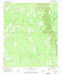
1971 Map of Sumpter
USGS Topo · Published 1973About this map
Sumpter and the rural stretches along the Saline River define the landscape of south-central Arkansas in the early 1970s. The map illustrates a region transitioning from its early rail-and-timber era, evidenced by the extensive Old Railroad Grade that winds through the terrain, to a landscape punctuated by gravel extraction and agriculture. Pockets of local history are preserved in sites like Pattsville, where both the Pattsville Cem and nearby Simpson stand as established community markers.
Find a feature on this map
21 named features on this map. Tap any name to fly to it.
Don’t see what you’re looking for? This feature index may not catch every label — zoom into the map to look around manually.
Map Details
Editions of this 1971 Sumpter Map
2 editions found
Other maps of this area

1934 · Ingalls
USGS Topo · 1:48,000

1937 · Ingalls
USGS Topo · 1:62,500

1939 · Ingalls
USGS Topo · 1:62,500

1953 · Greenwood
USGS Topo · 1:250,000

1953 · El Dorado
USGS Topo · 1:250,000

1956 · Greenwood
USGS Topo · 1:250,000

1957 · El Dorado
USGS Topo · 1:250,000

1958 · El Dorado
USGS Topo · 1:250,000

1960 · El Dorado
USGS Topo · 1:250,000
1971 · Vick
USGS Topo · 1:24,000