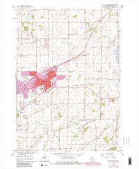
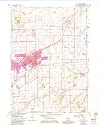
1962 Map of Sun Prairie
USGS Topo · Published 1983About this map
Sun Prairie stands as the primary hub of this 1960s Wisconsin landscape, characterized by the expansive urban growth that began to reach into the surrounding farmland by the early 1980s. The village center, focused around Angell Park and the intersection of local rail and road networks, transitions into a landscape of glacial topography and agricultural utility. The Chicago Milwaukee St Paul and Pacific railroad cuts a diagonal path through the terrain, connecting the town to the broader regional economy. Outside the main settlement, the area is dotted with local heritage sites like the Bristol Ch and Bristol Cem to the north, while the southern reaches feature the smaller hamlet of Pierceville. The eastern edge is defined by the Deansville State Wildlife Area, while various quarries and gravel pits suggest the active extraction of local resources from the rolling earth.
Find a feature on this map
30 named features on this map. Tap any name to fly to it.
Don’t see what you’re looking for? This feature index may not catch every label — zoom into the map to look around manually.
Map Details
Editions of this 1962 Sun Prairie Map
5 editions found
Other maps of this area

1890 · Madison
USGS Topo · 1:62,500

1890 · Sun Prairie
USGS Topo · 1:62,500

1892 · Madison
USGS Topo · 1:62,500

1896 · Sun Prairie
USGS Topo · 1:62,500

1901 · Poynette
USGS Topo · 1:62,500

1904 · Madison
USGS Topo · 1:62,500

1905 · Sun Prairie
USGS Topo · 1:62,500

1906 · Madison
USGS Topo · 1:62,500

1907 · Sun Prairie
USGS Topo · 1:62,500

1955 · Columbus
USGS Topo · 1:62,500