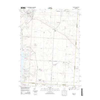
2013 Map of Sunbury
USGS Topo · Published 2013About this map
Sunbury anchors the northwestern corner of this Central Ohio landscape, where the town layout includes historic thoroughfares like W Granville St and S Columbus St. The region is defined by the drainage networks of Big Walnut Creek and its many branches, including the N Fork Rattlesnake Cr, S Fork Rattlesnake Cr, and E Fork Rattlesnake Cr. To the south, the expansive Hoover Reservoir reaches into the territory, while the Sunbury Upground Reservoir Number Two sits just north of the village.
Find a feature on this map
102 named features on this map. Tap any name to fly to it.
Don’t see what you’re looking for? This feature index may not catch every label — zoom into the map to look around manually.
Map Details
Editions of this 2013 Sunbury Map
This is the sole edition of this map. No revisions or reprints were ever made.
Other maps of this area

1902 · Westerville
USGS Topo · 1:62,500

1904 · Westerville
USGS Topo · 1:62,500

1908 · Granville
USGS Topo · 1:62,500

1910 · Granville
USGS Topo · 1:62,500

1915 · Marengo
USGS Topo · 1:62,500

1915 · Fredericktown
USGS Topo · 1:62,500

1943 · Marengo
USGS Topo · 1:62,500

1943 · Fredericktown
USGS Topo · 1:62,500

1950 · Marion
USGS Topo · 1:250,000
1954 · Northeast Columbus
USGS Topo · 1:24,000