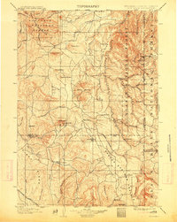
1902 Map of Sundance
USGS Topo · Published 1913About this map
Sundance serves as the focal point of this turn-of-the-century topographic study, situated at the edge of the Sundance National Forest. The landscape is a transition from the rolling plains into the mountainous terrain of the Black Hills National Forest along the South Dakota border. Settlement patterns are defined by isolated outposts and early ranching operations, such as Mc Creadys Ranch, Hotwell Ranch, and the T.E.Ranch. Mining activity is evident in the northeastern corner near the state line, with the small settlements of Welcome, Mineral Hill, and Tinton clustered around the high elevations of Nigger Hill. In the southwestern corner, the Burlington and Missouri River R.R. cuts through the territory, highlighting the early rail connections essential for the region's growth. The intricate network of canyons, including Grand Canyon and Spring Canyon, underscores the complex drainage systems feeding into Beaver Creek and Inyankara Creek.
Find a feature on this map
79 named features on this map. Tap any name to fly to it.
Don’t see what you’re looking for? This feature index may not catch every label — zoom into the map to look around manually.
Map Details
Editions of this 1902 Sundance Map
4 editions found
Other maps of this area

1894 · Deadwood
USGS Topo · 1:125,000

1896 · Harney Peak
USGS Topo · 1:125,000

1898 · Sundance
USGS Topo · 1:125,000

1899 · Newcastle
USGS Topo · 1:125,000

1900 · Spearfish
USGS Topo · 1:62,500

1901 · Harney Peak
USGS Topo · 1:125,000

1901 · Deadwood
USGS Topo · 1:125,000

1901 · Newcastle
USGS Topo · 1:125,000

1901 · Aladdin
USGS Topo · 1:125,000

1902 · Sundance
USGS Topo · 1:125,000