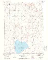
1951 Map of Sunken Lake
USGS Topo · Published 1979About this map
Jackson Reservoir dominates the southern portion of this high plains landscape in Morgan County, Colorado, where the waters of the State Recreation Area provided a stark contrast to the surrounding arid terrain. Surveyed in the early 1950s with later revisions, the map reveals a complex system of water management essential for prairie life, including the Riverside Canal and Valley Ditch.
Find a feature on this map
17 named features on this map. Tap any name to fly to it.
Don’t see what you’re looking for? This feature index may not catch every label — zoom into the map to look around manually.
Map Details
Editions of this 1951 Sunken Lake Map
3 editions found
Other maps of this area

1950 · Greasewood Lake
USGS Topo · 1:24,000

1950 · Masters
USGS Topo · 1:24,000

1951 · Masters
USGS Topo · 1:24,000

1951 · Weldona
USGS Topo · 1:24,000

1951 · Orchard
USGS Topo · 1:24,000

1951 · Sunken Lake
USGS Topo · 1:24,000

1951 · Judson Hills
USGS Topo · 1:24,000

1954 · Sterling
USGS Topo · 1:250,000

1954 · Greeley
USGS Topo · 1:250,000

1957 · Greeley
USGS Topo · 1:250,000