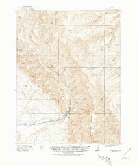
1915 Map of Sunnyside
USGS Topo · Published 1981About this map
The Denver and Rio Grande Western railroad corridor anchors the southern edge of this survey, following the drainage of Grassy Trail Creek as it moves through the high desert of Carbon County. This landscape is defined by the massive verticality of West Ridge and Patmos Mountain, where deep drainage systems like Whitmore Canyon and Horse Canyon carve through the Book Cliffs formation. At the base of these heights, Pierson Ranch provides a rare marker of early 20th-century settlement in an area largely characterized by industrial and ranching potential. The high-altitude terrain is marked by peaks such as Mt Bartles and Bruin Pt, which overlook a network of seasonal water sources including Willow Spring and North Spring. This map captures the region's topography just as the coal-rich canyons were being developed into critical hubs for the Utah rail economy.
Find a feature on this map
31 named features on this map. Tap any name to fly to it.
Don’t see what you’re looking for? This feature index may not catch every label — zoom into the map to look around manually.
Map Details
Editions of this 1915 Sunnyside Map
4 editions found
Other maps of this area

1886 · Price River
USGS Topo · 1:250,000

1896 · Price River
USGS Topo · 1:250,000

1915 · Sunnyside
USGS Topo · 1:62,500

1915 · Wellington
USGS Topo · 1:62,500

1948 · Woodside
USGS Topo · 1:62,500

1949 · Woodside
USGS Topo · 1:62,500

1950 · Woodside
USGS Topo · 1:62,500

1954 · Flat Canyon
USGS Topo · 1:62,500

1954 · Range Creek
USGS Topo · 1:62,500

1956 · Price
USGS Topo · 1:250,000
Featured Places
- Bruin Point, UT
- Sunnydale, East Carbon
- Columbia Junction, East Carbon
- Upper Sunnyside, UT
- East Carbon, UT