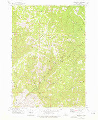
1972 Map of Sunset Mtn.
USGS Topo · Published 1976About this map
Boise National Forest contains a complex network of ridges and watercourses centered around Pilot Peak Lookout and Sunset Mtn. The 1971 aerial photography captured for this survey shows a landscape defined by its mining and recreational history, where the headwaters of Mores Creek and Grimes Creek are dotted with numerous mines and prospects. Several seasonal sites line the mountain drainages, including Hayfork Campground and Tenmile Campground, alongside landmarks like Mores Creek Summit. Transportation across this high-elevation terrain in the early 1970s relied on a system of jeep trails and pack trails that connect features such as Freeman Peak and Summit Flat. The nomenclature of the area reflects its gold-rush legacy, evidenced by names like American Girl Gulch and Whoop Um Up Creek.
Find a feature on this map
35 named features on this map. Tap any name to fly to it.
Don’t see what you’re looking for? This feature index may not catch every label — zoom into the map to look around manually.
Map Details
Editions of this 1972 Sunset Mtn. Map
3 editions found
Other maps of this area

1894 · Idaho Basin
USGS Topo · 1:125,000

1909 · Garden Valley
USGS Topo · 1:125,000

1955 · Hailey
USGS Topo · 1:250,000

1957 · Pioneerville
USGS Topo · 1:24,000

1957 · Idaho City
USGS Topo · 1:24,000

1957 · Challis
USGS Topo · 1:250,000

1959 · Hailey
USGS Topo · 1:250,000

1959 · Garden Valley
USGS Topo · 1:62,500

1960 · Challis
USGS Topo · 1:250,000

1962 · Hailey
USGS Topo · 1:250,000