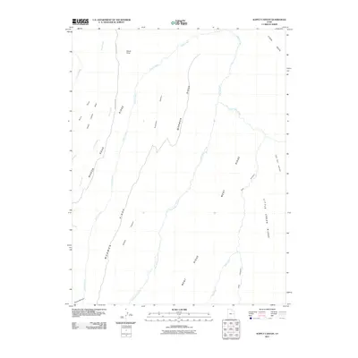
2011 Map of Supply Canyon
USGS Topo · Published 2011About this map
Mormon Ridge and Little Creek Ridge define the vertical relief of this high-plateau landscape, where a network of seasonal drainages has carved deep paths through the terrain. The presence of the Wagon Road and Sego Canyon Rd indicates established travel corridors that follow the natural topography of the canyons and ridge lines. To the west, the winding course of Pioche Creek and Corral Creek demonstrates the complex drainage patterns common in this part of Grand County. To the east, the map details the branching forks of West Willow Creek, East Willow Creek, and the primary Willow Creek, showing how these waterways have shaped Went Ridge and Steer Ridge. Significant landmarks like Windy Point and Draw Point provide fixed navigation points across this expansive system of canyons, including Supply Canyon and Fivemile Canyon.
Find a feature on this map
21 named features on this map. Tap any name to fly to it.
Don’t see what you’re looking for? This feature index may not catch every label — zoom into the map to look around manually.
Map Details
Editions of this 2011 Supply Canyon Map
This is the sole edition of this map. No revisions or reprints were ever made.
Other maps of this area

1885 · East Tavaputs
USGS Topo · 1:250,000

1956 · Grand Junction
USGS Topo · 1:250,000

1959 · Grand Junction
USGS Topo · 1:250,000

1960 · Grand Junction
USGS Topo · 1:250,000

1962 · Grand Junction
USGS Topo · 1:250,000

1963 · Tenmile Canyon
USGS Topo · 1:62,500

1963 · Moonwater Point
USGS Topo · 1:62,500
1963 · Floy Canyon
USGS Topo · 1:62,500

1963 · Sego Canyon
USGS Topo · 1:62,500

1964 · Grand Junction
USGS Topo · 1:250,000