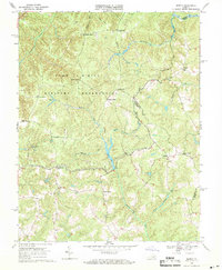
1968 Map of Supply
USGS Topo · Published 1971About this map
The Camp A P Hill Military Reservation occupies a massive portion of this landscape along the border of Caroline and Essex counties in the late 1960s. The map reveals a transition from these military lands to the farming communities and crossroad settlements to the east and south. Traditional gathering points like Ebenezer Ch and Enon Ch sit near the small village of Supply, while family names define numerous intersections such as Martins Corner, Goldmans Corner, and Daniel Corner.
Find a feature on this map
29 named features on this map. Tap any name to fly to it.
Don’t see what you’re looking for? This feature index may not catch every label — zoom into the map to look around manually.
Map Details
Editions of this 1968 Supply Map
4 editions found
Other maps of this area

1889 · Fredericksburg
USGS Topo · 1:125,000

1892 · Fredericksburg
USGS Topo · 1:125,000

1894 · Fredericksburg
USGS Topo · 1:125,000

1918 · Doswell
USGS Topo · 1:62,500

1918 · Aylett
USGS Topo · 1:62,500

1933 · Aylett
USGS Topo · 1:62,500

1942 · Bowling Green
USGS Topo · 1:31,680

1942 · Upper Zion
USGS Topo · 1:31,680

1942 · Occupacia
USGS Topo · 1:31,680

1942 · Rollins Fork
USGS Topo · 1:31,680