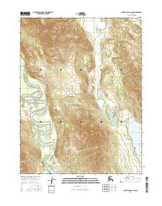
2016 Map of Survey Pass A-1 NW
USGS Topo · Published 2016About this map
The Alatna River snakes through the western portion of this landscape, its wandering oxbows and side channels defining the low-lying valley floor. This 2016 survey by the U.S. Geological Survey captures the intricate drainage patterns of the region, where the river's path is mirrored to the east by the smaller Tobuk Creek (also labeled Tobuk Cr). The terrain is dominated by the transition from riverine wetlands to the rising slopes of the Brooks Range foothills, with Iniakuk Lake situated in the southeastern corner. This map provides a clear record of the hydrography in the Yukon-Koyukuk region, illustrating how water shapes the interior Alaskan wilderness.
Find a feature on this map
9 named features on this map. Tap any name to fly to it.
Don’t see what you’re looking for? This feature index may not catch every label — zoom into the map to look around manually.
Map Details
Editions of this 2016 Survey Pass A-1 NW Map
This is the sole edition of this map. No revisions or reprints were ever made.
Other maps of this area

1951 · Survey Pass
USGS Topo · 1:250,000

1956 · Survey Pass
USGS Topo · 1:250,000

1964 · Survey Pass
USGS Topo · 1:250,000

1966 · Survey Pass
USGS Topo · 1:250,000
1986 · Survey Pass A-1
USGS Topo · 1:63,360
1986 · Survey Pass B-2
USGS Topo · 1:63,360
1986 · Survey Pass B-1
USGS Topo · 1:63,360
1986 · Survey Pass A-2
USGS Topo · 1:63,360
2016 · Survey Pass A-2 NE
USGS Topo · 1:25,000
2016 · Survey Pass A-2 SE
USGS Topo · 1:25,000