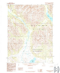
1986 Map of Survey Pass A-4
USGS Topo · Published 1986About this map
The Reed River valley serves as the central drainage for this remote arctic landscape, captured in a 1986 USGS survey that reflects the land management shifts of the era. The area is defined by the high-alpine transitions within the Gates of the Arctic National Park, including designated Gates of the Arctic Wilderness and the Gates of the Arctic National Preserve. These boundaries were established following the Alaska National Interest Lands Conservation Act of 1980, making this map a primary document for the newly formalized federal protection of the Brooks Range. Notable water bodies such as Walker Lake in the northeast and Nutuvukti Lake in the south anchor the drainages of Inyuktuk Creek and Kaluluktok Creek, illustrating a wilderness landscape where natural watercourses and topography are the only landmarks, entirely devoid of roads or permanent settlements.
Find a feature on this map
8 named features on this map. Tap any name to fly to it.
Don’t see what you’re looking for? This feature index may not catch every label — zoom into the map to look around manually.
Map Details
Editions of this 1986 Survey Pass A-4 Map
2 editions found
Other maps of this area

1951 · Hughes
USGS Topo · 1:250,000

1951 · Survey Pass
USGS Topo · 1:250,000

1956 · Hughes
USGS Topo · 1:250,000

1956 · Survey Pass
USGS Topo · 1:250,000

1964 · Survey Pass
USGS Topo · 1:250,000

1964 · Hughes
USGS Topo · 1:250,000

1965 · Hughes
USGS Topo · 1:250,000

1966 · Survey Pass
USGS Topo · 1:250,000
1986 · Survey Pass A-5
USGS Topo · 1:63,360
1986 · Survey Pass A-4
USGS Topo · 1:63,360