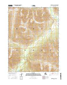
2016 Map of Survey Pass A-5 NE
USGS Topo · Published 2016About this map
Akurekvik Pass serves as a natural corridor through the high-altitude terrain of the Northwest Arctic, illustrating the topographic isolation of this northern landscape. The map records a complex drainage system where the Reed River flows through the northeast corner, while the headwaters of Beaver Creek (labeled in parts as Beaver Cr) wind through the southern and western reaches. This area is defined by its lack of permanent settlements or infrastructure, organized instead by the Public Land Survey System boundaries of t21n r17e, t21n r16e, t20n r17e, and t20n r18e. The absence of roads or established trails highlights a wilderness state that remains essentially unchanged in its geographic character since the mid-20th century, making it a critical reference for understanding the hydrological patterns and high-latitude passes of the Brooks Range region.
Find a feature on this map
8 named features on this map. Tap any name to fly to it.
Don’t see what you’re looking for? This feature index may not catch every label — zoom into the map to look around manually.
Map Details
Editions of this 2016 Survey Pass A-5 NE Map
This is the sole edition of this map. No revisions or reprints were ever made.
Other maps of this area

1951 · Survey Pass
USGS Topo · 1:250,000

1956 · Survey Pass
USGS Topo · 1:250,000

1964 · Survey Pass
USGS Topo · 1:250,000

1966 · Survey Pass
USGS Topo · 1:250,000
1986 · Survey Pass A-5
USGS Topo · 1:63,360
1986 · Survey Pass A-4
USGS Topo · 1:63,360
1990 · Survey Pass B-5
USGS Topo · 1:63,360
1990 · Survey Pass B-4
USGS Topo · 1:63,360
2016 · Survey Pass B-5 SE
USGS Topo · 1:25,000
2016 · Survey Pass A-5 NW
USGS Topo · 1:25,000