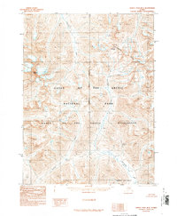
1990 Map of Survey Pass B-4
USGS Topo · Published 1990About this map
Mount Igikpak dominates the western topography of this Brooks Range interior, marking a high point in a landscape defined by the Continental Divide. This 1990 provisional survey documents the protected reaches of Gates of the Arctic National Park and the Gates of the Arctic Wilderness before the turn of the century. The drainage patterns are clearly delineated, showing the northern flow of the Noatak River and the southern paths of Kaluluktok Creek and Inyuilak Creek. Small, isolated labels such as Walker and Akure indicate human presence in the southern portion of the quadrangle. The map captures the fundamental transition at Akabluak Pass, where the terrain splits between major watersheds in the Northwest Arctic Borough.
Find a feature on this map
11 named features on this map. Tap any name to fly to it.
Don’t see what you’re looking for? This feature index may not catch every label — zoom into the map to look around manually.
Map Details
Editions of this 1990 Survey Pass B-4 Map
This is the sole edition of this map. No revisions or reprints were ever made.
Other maps of this area

1951 · Survey Pass
USGS Topo · 1:250,000

1956 · Survey Pass
USGS Topo · 1:250,000

1964 · Survey Pass
USGS Topo · 1:250,000

1966 · Survey Pass
USGS Topo · 1:250,000
1986 · Survey Pass A-5
USGS Topo · 1:63,360
1986 · Survey Pass A-4
USGS Topo · 1:63,360
1986 · Survey Pass C-3
USGS Topo · 1:63,360
1986 · Survey Pass A-3
USGS Topo · 1:63,360
1986 · Survey Pass C-4
USGS Topo · 1:63,360
1990 · Survey Pass B-5
USGS Topo · 1:63,360