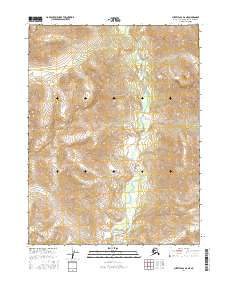
2016 Map of Survey Pass A-6 NE
USGS Topo · Published 2016About this map
The Mauneluk River defines the central valley of this Arctic landscape, winding through a complex system of drainage and relief. This 2016 survey, produced by the U.S. Geological Survey, illustrates the hydrologic patterns and topography of the Northwest Arctic Borough in high detail. The map is organized by the Public Land Survey System, covering portions of t21n r14e, t21n r15e, t20n r14e, and t20n r15e. These township and range designations provide the essential grid for locating specific land parcels and geographical features in a region defined more by its natural watercourses and elevation changes than by human infrastructure or settlements.
Find a feature on this map
5 named features on this map. Tap any name to fly to it.
Don’t see what you’re looking for? This feature index may not catch every label — zoom into the map to look around manually.
Map Details
Editions of this 2016 Survey Pass A-6 NE Map
This is the sole edition of this map. No revisions or reprints were ever made.
Other maps of this area

1951 · Survey Pass
USGS Topo · 1:250,000

1956 · Survey Pass
USGS Topo · 1:250,000

1964 · Survey Pass
USGS Topo · 1:250,000

1966 · Survey Pass
USGS Topo · 1:250,000
1986 · Survey Pass A-5
USGS Topo · 1:63,360
1986 · Survey Pass A-6
USGS Topo · 1:63,360
1990 · Survey Pass B-5
USGS Topo · 1:63,360
1990 · Survey Pass B-6
USGS Topo · 1:63,360
2016 · Survey Pass A-5 NW
USGS Topo · 1:25,000
2016 · Survey Pass B-6 SE
USGS Topo · 1:25,000