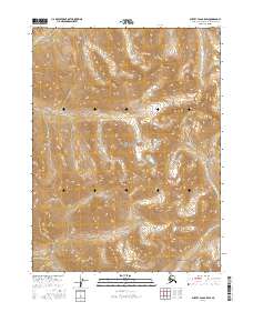
2016 Map of Survey Pass B-5 SW
USGS Topo · Published 2016About this map
Gates Of The Arctic National Park encompasses the majority of this high-latitude terrain, preserving a landscape defined by the drainage systems of the Central Brooks Range. The headwaters of the Mauneluk River emerge in the northwest, carving through steep elevation gradients before trending westward. Further east, Angunelechak Pass serves as a critical topographic notch between high ridges, while Angayutak Cr drains the northeastern slopes. This survey provides a precise look at the interior wilderness where drainage patterns and mountain passes dictated movement through the Arctic interior. The map is largely structured around the township and range lines of t22n r16e, documenting the administrative boundaries within this protected federal territory during the early 21st century.
Find a feature on this map
10 named features on this map. Tap any name to fly to it.
Don’t see what you’re looking for? This feature index may not catch every label — zoom into the map to look around manually.
Map Details
Editions of this 2016 Survey Pass B-5 SW Map
This is the sole edition of this map. No revisions or reprints were ever made.
Other maps of this area

1951 · Survey Pass
USGS Topo · 1:250,000

1956 · Survey Pass
USGS Topo · 1:250,000

1964 · Survey Pass
USGS Topo · 1:250,000

1966 · Survey Pass
USGS Topo · 1:250,000
1986 · Survey Pass A-5
USGS Topo · 1:63,360
1986 · Survey Pass A-6
USGS Topo · 1:63,360
1990 · Survey Pass B-5
USGS Topo · 1:63,360
1990 · Survey Pass B-6
USGS Topo · 1:63,360
2016 · Survey Pass B-5 NW
USGS Topo · 1:25,000
2016 · Survey Pass B-5 SE
USGS Topo · 1:25,000