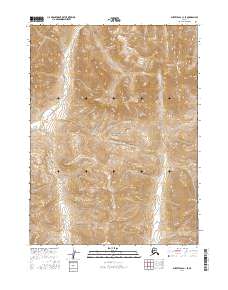
2016 Map of Survey Pass C-1 SE
USGS Topo · Published 2016About this map
Gates of the Arctic National Park encompasses this expansive wilderness in northern Alaska, where the Nahtuk River winds through the central valley floors. The landscape is defined by significant elevation changes, anchored by the prominent peak of Nahtuk Mtn, which serves as a central landmark for this drainage basin. To the east, the Iniakuk River flows southward through tight mountain passes, joined by smaller tributaries like Dawn Cr. This survey illustrates the protected, roadless character of the Brooks Range interior, showing a region where natural watercourses and topography remain the primary features. The absence of human settlements or infrastructure emphasizes the primitive state of the land as it was documented in the early 21st century.
Find a feature on this map
11 named features on this map. Tap any name to fly to it.
Don’t see what you’re looking for? This feature index may not catch every label — zoom into the map to look around manually.
Map Details
Editions of this 2016 Survey Pass C-1 SE Map
This is the sole edition of this map. No revisions or reprints were ever made.
Other maps of this area

1951 · Survey Pass
USGS Topo · 1:250,000

1951 · Wiseman
USGS Topo · 1:250,000

1956 · Wiseman
USGS Topo · 1:250,000

1956 · Survey Pass
USGS Topo · 1:250,000

1964 · Survey Pass
USGS Topo · 1:250,000

1964 · Wiseman
USGS Topo · 1:250,000

1966 · Survey Pass
USGS Topo · 1:250,000
1986 · Wiseman C-6
USGS Topo · 1:63,360
1986 · Survey Pass C-1
USGS Topo · 1:63,360
1986 · Wiseman B-6
USGS Topo · 1:63,360