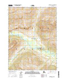
2016 Map of Survey Pass C-3 SE
USGS Topo · Published 2016About this map
The Endicott Mountains dominate the northern landscape of this interior wilderness, located within the protected boundary of Gates of the Arctic National Park. This survey captures a remote subarctic environment defined by the confluence of major glacial drainage systems. The Unakserak River flows southward through a wide glacial valley to join the Alatna River, a significant waterway that meanders through the central portion of the map. These rivers, along with the tributary Aulinyak Creek, represent the primary travel corridors in a region devoid of roads or permanent settlements. The topographic detail reveals the complex hydrology of the valley floors, where the rivers split into braided channels and seasonal wetlands, illustrating the shifting nature of these arctic watercourses before they reach the Koyukuk River basin.
Find a feature on this map
13 named features on this map. Tap any name to fly to it.
Don’t see what you’re looking for? This feature index may not catch every label — zoom into the map to look around manually.
Map Details
Editions of this 2016 Survey Pass C-3 SE Map
This is the sole edition of this map. No revisions or reprints were ever made.
Other maps of this area

1951 · Survey Pass
USGS Topo · 1:250,000

1956 · Survey Pass
USGS Topo · 1:250,000

1964 · Survey Pass
USGS Topo · 1:250,000

1966 · Survey Pass
USGS Topo · 1:250,000
1986 · Survey Pass C-2
USGS Topo · 1:63,360
1986 · Survey Pass C-3
USGS Topo · 1:63,360
1986 · Survey Pass B-2
USGS Topo · 1:63,360
1990 · Survey Pass B-3
USGS Topo · 1:63,360
2016 · Survey Pass C-2 NW
USGS Topo · 1:25,000
2016 · Survey Pass B-3 NE
USGS Topo · 1:25,000