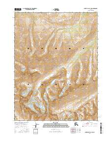
2016 Map of Survey Pass B-3 NE
USGS Topo · Published 2016About this map
Gates of the Arctic National Park encompasses this remote stretch of the Brooks Range, dominated by the jagged granite spires of the Arrigetch Peaks. This 2016 survey illustrates the dramatic alpine topography where glacier-carved cirques and steep ridges define the headwaters of the region. The drainage of Arrigetch Cr flows through the high-elevation valleys, cutting through the township lines of t24n r21e and t24n r22e. The map serves as a detailed topographic record of one of the most wilderness-oriented landscapes in Alaska, showing precise contour intervals that trace the extreme vertical relief of the peaks. Settlement and infrastructure are entirely absent, highlighting the area's status as a protected wilderness where the land remains shaped solely by geological and glacial processes.
Find a feature on this map
7 named features on this map. Tap any name to fly to it.
Don’t see what you’re looking for? This feature index may not catch every label — zoom into the map to look around manually.
Map Details
Editions of this 2016 Survey Pass B-3 NE Map
This is the sole edition of this map. No revisions or reprints were ever made.
Other maps of this area

1951 · Survey Pass
USGS Topo · 1:250,000

1956 · Survey Pass
USGS Topo · 1:250,000

1964 · Survey Pass
USGS Topo · 1:250,000

1966 · Survey Pass
USGS Topo · 1:250,000
1986 · Survey Pass C-2
USGS Topo · 1:63,360
1986 · Survey Pass C-3
USGS Topo · 1:63,360
1986 · Survey Pass B-2
USGS Topo · 1:63,360
1990 · Survey Pass B-3
USGS Topo · 1:63,360
2016 · Survey Pass B-3 SE
USGS Topo · 1:25,000
2016 · Survey Pass C-3 SE
USGS Topo · 1:25,000