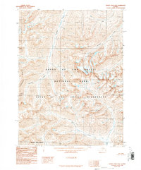
1990 Map of Survey Pass B-3
USGS Topo · Published 1990About this map
Arrigetch Peaks dominate this high-altitude landscape within the Gates Of The Arctic National Park, where sharp granite spires overlook the drainage basins of the far north. The topographic detail follows the Continental Divide as it winds through the Gates Of The Arctic Wilderness, marking the primary hydrological separation of the region. This 1990 provisional edition, compiled from aerial photography taken in the late 1970s and early 1980s, reveals a territory devoid of roads or permanent settlements, defined instead by its glacial valleys and river systems. The headwaters of the Kobuk River flow from the south, while glacier-fed streams like Awlinyak Creek and Arrigetch Creek carve deep into the mountain range. The map also delineates the administrative boundary of the Northwest Arctic Borough where it meets the interior wilderness.
Find a feature on this map
8 named features on this map. Tap any name to fly to it.
Don’t see what you’re looking for? This feature index may not catch every label — zoom into the map to look around manually.
Map Details
Editions of this 1990 Survey Pass B-3 Map
This is the sole edition of this map. No revisions or reprints were ever made.
Other maps of this area

1951 · Survey Pass
USGS Topo · 1:250,000

1956 · Survey Pass
USGS Topo · 1:250,000

1964 · Survey Pass
USGS Topo · 1:250,000

1966 · Survey Pass
USGS Topo · 1:250,000
1986 · Survey Pass A-4
USGS Topo · 1:63,360
1986 · Survey Pass C-2
USGS Topo · 1:63,360
1986 · Survey Pass C-3
USGS Topo · 1:63,360
1986 · Survey Pass B-2
USGS Topo · 1:63,360
1986 · Survey Pass A-3
USGS Topo · 1:63,360
1986 · Survey Pass C-4
USGS Topo · 1:63,360