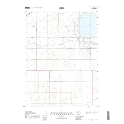
2017 Map of Sutherland Reservoir West
USGS Topo · Published 2017About this map
Sutherland Reservoir dominates the northeastern corner of this Nebraska landscape, serving as a primary focal point for the region's managed water systems. The reservoir is fed and interconnected by the Sutherland Canal, which winds through the central township, illustrating the critical role of irrigation and water transport in the Platte River valley. The surrounding terrain is organized by a systematic grid of section lines and rural routes, including the prominent W Correction Line Rd and W State Farm Rd. These roads provide access to the undulating plains that define Lincoln County, where the transition from managed waterways to open prairie is evident. Local thoroughfares such as W Goedert-White Rd and Antelope Rd reflect the enduring agricultural character of the area, connecting scattered homesteads and farming operations within townships T13N R34W and T12N R34W.
Find a feature on this map
30 named features on this map. Tap any name to fly to it.
Don’t see what you’re looking for? This feature index may not catch every label — zoom into the map to look around manually.
Map Details
Editions of this 2017 Sutherland Reservoir West Map
This is the sole edition of this map. No revisions or reprints were ever made.
Other maps of this area

1898 · Paxton
USGS Topo · 1:125,000

1901 · Paxton
USGS Topo · 1:125,000

1954 · McCook
USGS Topo · 1:250,000

1954 · North Platte
USGS Topo · 1:250,000

1956 · North Platte
USGS Topo · 1:250,000

1957 · North Platte
USGS Topo · 1:250,000

1957 · McCook
USGS Topo · 1:250,000

1958 · McCook
USGS Topo · 1:250,000

1967 · North Platte
USGS Topo · 1:250,000

1971 · Sutherland Reservoir West
USGS Topo · 1:24,000