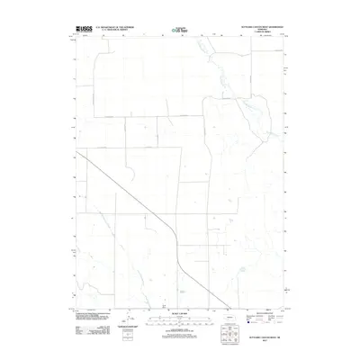
2011 Map of Suttlers Canyon West
USGS Topo · Published 2011About this map
Red Willow Creek winds through the northern reaches of this rural Lincoln County landscape, defining the local drainage alongside Little Blackwood Creek to the south. This 2011 survey illustrates a sparse, wide-open agricultural environment where land divisions are clearly marked by a systematic network of section roads. The map highlights the essential infrastructure of this high plains region, including Scott Dam and several prominent thoroughfares such as S Prairie Trace Rd and W Gibson Rd. These routes, along with S Rubbie Rd and S O Fallon Rd, underscore the structured settlement patterns typical of Nebraska’s ranching and farming country. The proximity of W Brushy Rd and W Willow Rd further indicates the naming conventions tied to the area's natural hydrology and vegetation during the early 21st century.
Find a feature on this map
12 named features on this map. Tap any name to fly to it.
Don’t see what you’re looking for? This feature index may not catch every label — zoom into the map to look around manually.
Map Details
Editions of this 2011 Suttlers Canyon West Map
This is the sole edition of this map. No revisions or reprints were ever made.
Other maps of this area

1954 · McCook
USGS Topo · 1:250,000

1956 · Dickens
USGS Topo · 1:24,000

1957 · McCook
USGS Topo · 1:250,000

1958 · McCook
USGS Topo · 1:250,000

1973 · Suttlers Canyon East
USGS Topo · 1:24,000

1973 · Suttlers Canyon West
USGS Topo · 1:24,000
1973 · Melton Ranch Airport
USGS Topo · 1:24,000
1973 · Wallace
USGS Topo · 1:24,000

1973 · Hayes Center NW
USGS Topo · 1:24,000

1974 · Hayes Center
USGS Topo · 1:24,000