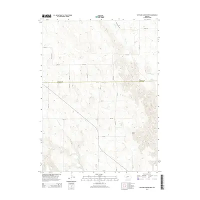
2014 Map of Suttlers Canyon West
USGS Topo · Published 2014About this map
Suttlers Canyon and the surrounding high plains of southwestern Nebraska are defined by a network of ephemeral drainages and rural sections lines at the Lincoln County and Hayes County border. The landscape is primarily shaped by the winding courses of Red Willow Cr in the north and Little Blackwood Cr in the south, which cut through the tablelands. Man-made interventions in this cattle-ranching landscape are visible through the presence of Scott Reservoir and a grid of access routes like W Arrow Mule Shoe Rd and S Prairie Trace Rd. This 2014 survey documents the persistence of large-scale landholdings and the sparse infrastructure typical of the Nebraska Sandhills transition zone, where naming conventions like Bubble Rd and O'Fallon Rd often reflect local family legacies or natural landmarks.
Find a feature on this map
25 named features on this map. Tap any name to fly to it.
Don’t see what you’re looking for? This feature index may not catch every label — zoom into the map to look around manually.
Map Details
Editions of this 2014 Suttlers Canyon West Map
This is the sole edition of this map. No revisions or reprints were ever made.
Other maps of this area

1954 · McCook
USGS Topo · 1:250,000

1956 · Dickens
USGS Topo · 1:24,000

1957 · McCook
USGS Topo · 1:250,000

1958 · McCook
USGS Topo · 1:250,000

1973 · Suttlers Canyon East
USGS Topo · 1:24,000

1973 · Suttlers Canyon West
USGS Topo · 1:24,000
1973 · Melton Ranch Airport
USGS Topo · 1:24,000
1973 · Wallace
USGS Topo · 1:24,000

1973 · Hayes Center NW
USGS Topo · 1:24,000

1974 · Hayes Center
USGS Topo · 1:24,000