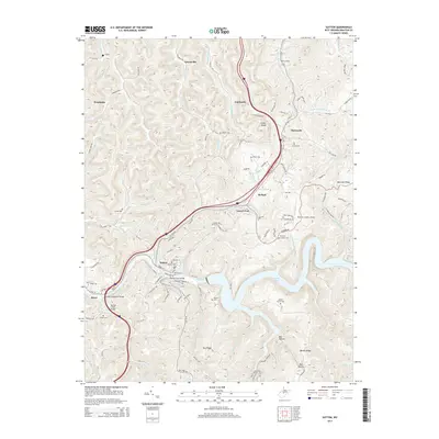
2014 Map of Sutton
USGS Topo · Published 2014About this map
The Elk River winds through this Central West Virginia landscape, anchoring the town of Sutton and the expansive Sutton Lake reservoir. The town’s historical infrastructure is evident in the Sutton Truss Bridge and the Sutton/Gassaway Bridge, which connect the community across the river’s steep banks. To the north, the corridor following the interstate includes the settlements of Flatwoods and McNutt, while the rural uplands are marked by numerous family burial grounds such as Camden Hill Cem, Ellison Cem, and the Morton Family Cem. The terrain is characterized by a series of high ridges including Barker Ridge and Bug Ridge, separated by deep hollows and creek forks. Transportation patterns are defined by the winding course of the river and the more modern alignment of the highway, which passes near Fisher Knob and the Braxton County Airport. Smaller communities like Lloydsville, Pembroke, and Fairbanks are situated among the intricate network of runs and forks that feed the main river valley.
Find a feature on this map
102 named features on this map. Tap any name to fly to it.
Don’t see what you’re looking for? This feature index may not catch every label — zoom into the map to look around manually.
Map Details
Editions of this 2014 Sutton Map
This is the sole edition of this map. No revisions or reprints were ever made.
Other maps of this area

1893 · Sutton
USGS Topo · 1:125,000

1906 · Glenville
USGS Topo · 1:62,500

1906 · Burnsville
USGS Topo · 1:62,500

1908 · Gassaway
USGS Topo · 1:48,000

1908 · Sutton
USGS Topo · 1:48,000

1910 · Sutton Special
USGS Topo · 1:62,500

1910 · Gassaway
USGS Topo · 1:62,500

1925 · Glenville
USGS Topo · 1:62,500

1925 · Burnsville
USGS Topo · 1:62,500

1927 · Burnsville
USGS Topo · 1:62,500