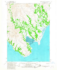
1963 Map of Sutwik Island D-4
USGS Topo · Published 1968About this map
Cape Kunmik anchors the southern coastline of this 1963 survey, where the terrestrial landscape meets the Pacific Ocean. This coastal segment of the Alaska Peninsula is defined by its dramatic drainage systems and prominent landmarks, such as The Twins rising between the watersheds. The mapping reflects a landscape of untouched drainage networks, where Yantarni Creek is fed by its North Fork and the aptly named Misery Creek. To the east, the deep indentation of Yantarni Bay contrasts with the broader curve of Amber Bay to the west. While no roads or trails are noted in this area, the inclusion of soundings and coastal features like Beak, Extra, and Kunmik underscores the primary importance of maritime navigation and coastal positioning in this era of Alaskan exploration.
Find a feature on this map
15 named features on this map. Tap any name to fly to it.
Don’t see what you’re looking for? This feature index may not catch every label — zoom into the map to look around manually.
Map Details
Editions of this 1963 Sutwik Island D-4 Map
This is the sole edition of this map. No revisions or reprints were ever made.
Other maps of this area

1943 · Ugashik
USGS Topo · 1:250,000

1948 · Ugashik
USGS Topo · 1:250,000

1949 · Ugashik
USGS Topo · 1:250,000

1951 · Sutwik Island
USGS Topo · 1:250,000

1954 · Ugashik A-3
USGS Topo · 1:63,360

1954 · Sutwik Island D-3
USGS Topo · 1:63,360

1963 · Ugashik A-4
USGS Topo · 1:63,360
1963 · Sutwik Island C-4
USGS Topo · 1:63,360

1963 · Sutwik Island
USGS Topo · 1:250,000
1963 · Sutwik Island C-5
USGS Topo · 1:63,360