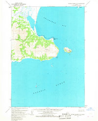
1963 Map of Sutwik Island C-5
USGS Topo · Published 1968About this map
Cape Kumlik dominates the coastline of this mid-century Alaskan survey, reaching out into the Pacific Ocean where it forms the southern boundary of Aniakchak Bay. The landscape is defined by its watercourses, including the north-flowing Black Creek and the southern drainage of Wolverine Creek. Signs of human presence in this remote environment are sparse, indicated by a small Village and isolated Cabin sites near the shore. These sparse settlements suggest a seasonal or subsistence-based presence typical of the region's mid-century character. Offshore, Kumlik Island and the rocky protrusion of Elephant Head Point provide navigational reference points along a shoreline shaped by a Lagoon and shifting Beach lines. The topography reveals a complex network of coastal swamps and low-relief terrain, interpreted from 1957 aerial photography.
Find a feature on this map
15 named features on this map. Tap any name to fly to it.
Don’t see what you’re looking for? This feature index may not catch every label — zoom into the map to look around manually.
Map Details
Editions of this 1963 Sutwik Island C-5 Map
2 editions found
Other maps of this area

1951 · Sutwik Island
USGS Topo · 1:250,000

1963 · Sutwik Island B-6
USGS Topo · 1:63,360
1963 · Sutwik Island C-4
USGS Topo · 1:63,360

1963 · Sutwik Island
USGS Topo · 1:250,000

1963 · Sutwik Island C-6
USGS Topo · 1:63,360
1963 · Sutwik Island D-5
USGS Topo · 1:63,360
1963 · Sutwik Island D-6
USGS Topo · 1:63,360
1963 · Sutwik Island D-4
USGS Topo · 1:63,360
2019 · Sutwik Island D-4 SW
USGS Topo · 1:25,000
2019 · Sutwik Island C-5 SW
USGS Topo · 1:25,000