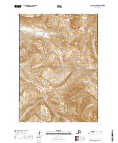
2019 Map of Sutwik Island D-5 NW
USGS Topo · Published 2019About this map
Aniakchak National Preserve dominates this terrain on the Alaska Peninsula, where dramatic topographic contours trace the descent from volcanic highlands toward the Bristol Bay lowlands. The drainage network is the defining characteristic of this landscape, led by the Cinder River in the central valley and the Aniakchak Wild and Scenic River, which flows through the southwestern corner. These protected waters reflect the federal conservation efforts of the late 20th and early 21st centuries. The presence of the Aniakchak River and its smaller tributaries like Wiggly Cr illustrates a highly active hydrological environment within a remote, undeveloped section of the t37s r52w and t38s r53w survey townships. The map provides a detailed record of the natural braided river patterns and complex elevations before any significant modern encroachment.
Find a feature on this map
10 named features on this map. Tap any name to fly to it.
Don’t see what you’re looking for? This feature index may not catch every label — zoom into the map to look around manually.
Map Details
Editions of this 2019 Sutwik Island D-5 NW Map
This is the sole edition of this map. No revisions or reprints were ever made.
Other maps of this area

1943 · Ugashik
USGS Topo · 1:250,000

1948 · Ugashik
USGS Topo · 1:250,000

1949 · Ugashik
USGS Topo · 1:250,000

1951 · Sutwik Island
USGS Topo · 1:250,000

1963 · Ugashik A-6
USGS Topo · 1:63,360

1963 · Sutwik Island
USGS Topo · 1:250,000
1963 · Sutwik Island D-5
USGS Topo · 1:63,360
1963 · Sutwik Island D-6
USGS Topo · 1:63,360
1963 · Ugashik A-5
USGS Topo · 1:63,360

1963 · Ugashik
USGS Topo · 1:250,000