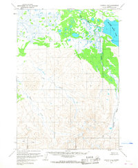
1963 Map of Ugashik A-5
USGS Topo · Published 1968About this map
Mother Goose Lake dominates the northeastern corner of this sub-arctic landscape, serving as a primary water source for the King Salmon River. The terrain transitions sharply from the low-lying, marshy wetlands surrounding the lake and the Painter Creek drainage to the high, relief-heavy ridges to the south and west. A single, isolated Cabin is marked near the southeastern shore of the lake, indicating the minimal human footprint in this wilderness during the early 1960s. Braided water systems like Old Creek, Pumice Creek, and Ray Creek carve through the southern uplands, illustrating the complex drainage patterns of the Alaska Peninsula. This survey reflects a time before extensive development, where Land lines were predetermined by the Bureau of Land Management but remained largely unsurveyed on the ground.
Find a feature on this map
7 named features on this map. Tap any name to fly to it.
Don’t see what you’re looking for? This feature index may not catch every label — zoom into the map to look around manually.
Map Details
Editions of this 1963 Ugashik A-5 Map
2 editions found
Other maps of this area

1943 · Ugashik
USGS Topo · 1:250,000

1948 · Ugashik
USGS Topo · 1:250,000

1949 · Ugashik
USGS Topo · 1:250,000

1951 · Sutwik Island
USGS Topo · 1:250,000

1954 · Ugashik B-4
USGS Topo · 1:63,360

1954 · Ugashik B-5
USGS Topo · 1:63,360

1963 · Ugashik B-6
USGS Topo · 1:63,360

1963 · Ugashik A-6
USGS Topo · 1:63,360

1963 · Ugashik A-4
USGS Topo · 1:63,360

1963 · Sutwik Island
USGS Topo · 1:250,000