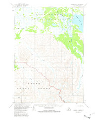
1963 Map of Ugashik A-5
USGS Topo · Published 1982About this map
The Alaska Peninsula National Wildlife Refuge dominates the northern half of this landscape, characterized by the expansive Mother Goose Lake and the winding King Salmon River. The terrain transitions southward into the volcanic and mountainous territory of the Aniakchak National Preserve. This area, mapped in the early 1960s, shows a remote wilderness where human activity is sparse, marked only by a solitary Cabin and a remote Landing Strip along Painter Creek. The drainage patterns are defined by numerous seasonal flows, including Old Creek, Pumice Creek, and Ray Creek, which carve through the high elevations. The map serves as a detailed record of this subarctic environment before modern environmental classifications and boundary adjustments were finalized.
Find a feature on this map
11 named features on this map. Tap any name to fly to it.
Don’t see what you’re looking for? This feature index may not catch every label — zoom into the map to look around manually.
Map Details
Editions of this 1963 Ugashik A-5 Map
2 editions found
Other maps of this area

1943 · Ugashik
USGS Topo · 1:250,000

1948 · Ugashik
USGS Topo · 1:250,000

1949 · Ugashik
USGS Topo · 1:250,000

1951 · Sutwik Island
USGS Topo · 1:250,000

1954 · Ugashik B-4
USGS Topo · 1:63,360

1954 · Ugashik B-5
USGS Topo · 1:63,360

1963 · Ugashik B-6
USGS Topo · 1:63,360

1963 · Ugashik A-6
USGS Topo · 1:63,360

1963 · Ugashik A-4
USGS Topo · 1:63,360

1963 · Sutwik Island
USGS Topo · 1:250,000